| Category | Assignment | Subject | Education |
|---|---|---|---|
| University | University of Southern Queensland | Module Title | SVY2202 Photogrammetry and Drone Mapping |
| Assessment Title | Assignment 2 |
|---|---|
| Academic Year | 2025-26 |

PLEASE NOTE: This document do not contain the full information for each assessment piece. The sample datasets, and supporting videos are all contained the relevant section on the course Studydesk.
1. The assignment file(s) must be submitted by 11.55 pm on the due date using UniSQ time (as displayed on the clock on the course home page; that is, Australian Eastern Standard Time).
2. The assignment must be submitted electronically as a portable document format (pdf) file via the Assignment submission link provided on the Course homepage (StudyDesk). Please use the file naming convention “last name_initial_AssignNo_SVY2202.pdf”, e.g. “Smith_A_Assign2_SVY2202.pdf”.
3. UniSQ policies about assessments (including submission, extension, and penalties for late submission) can be found at this link. An excerpt regarding penalties for late submission is provided below: “Assessment Items given marked Grades and submitted after the published due date without an approved extension or submitted after the revised due date where an extension has been granted, will incur a penalty of 5% of the Mark awarded to the Student, per Calendar Day late. For example, if the Student receives 35 marks out of a possible 50 marks for an Assessment Item that is submitted three (3) Calendar Days late, 15% of the Student's mark (3 days x 5% per day x 35 marks) will be deducted (5.25 marks). UniSQ Page 2 of 10 Assessment Items submitted more than 10 Calendar Days after the published due date without an approved extension, or more than 10 Calendar Days after the revised due date where an extension has been granted, will receive a Mark of zero.”
4. Present your answers in a format that enhances readability and depicts a professionally done work. There will be mark deduction for poor presentation (refer to Marking Rubric for details).
5. Assignment answers must be written in your own words. Avoid copy-and-paste scheme as plagiarism is taken very seriously. Use correct reference citations by using the Harvard AGPS referencing style . There will be mark deduction for missing or improper referencing (refer to Marking Rubric for details).
6. The use of artificial intelligence (AI) tool or technology (e.g. ChatGPT, Quillbot, Textero AI, Jasper AI, etc.) to answer any question (in part or in full) in this Assignment constitutes an academic misconduct. Any work flagged as suspicious will be subjected to a detailed check.
7. If you have questions/clarifications about the Assignment questions, please send them to the course Study Desk under the “Forums”, specifically to the “Assignment questions” thread.
1. Citing reference is required for any ideas/concepts/information obtained from external sources. Be aware that referencing is not about copying ‘word for word’ from a reference. It is about obtaining ideas/concepts/information and presenting it in your own words (i.e. paraphrasing) while acknowledging the source as a reference.
2. Listing the references at the end does not mean you have used them. The intext citation is critical whenever you use those references. If you are unsure about the method of in-text citation, please refer to the Harvard AGPS referencing guide in web link indicated above.
3. Do not put Web references (URLs) within the text. Instead, identify the author/owner of the Web site and cite it in-text while providing full details in the reference list.
4. Do not provide references after each question. A full reference list should be provided in alphabetical order at the end of the Assignment document.
5. References are not included in the word count.
This assignment is designed to enhance practical knowledge of GCP utilisation in drone mapping and its influence on the accuracy of the final output.
Follow the steps below to complete the assignment:
I. Setup for Analysis:
II. Processing and Analysing Images:
a) Process your selected images with Agisoft Metashape. Evaluate how different GCP configurations affect the accuracy of checkpoints A2, C2 (coordinates X, Y, Z).

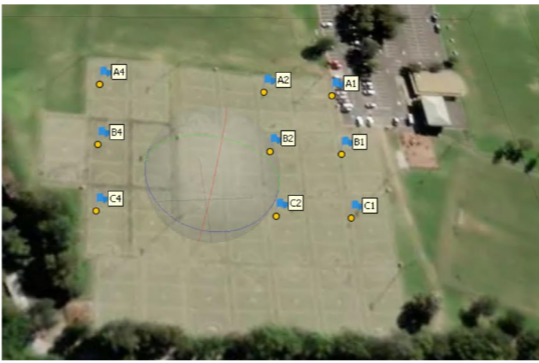
Figure 1: Layout of Ground Control Points (GCPs) and checkpoints over the chosen area, using drone imagery supplied by Position Partners with permission
Display the GCP section of Agisoft's processing report for each configuration:
Attach screenshots of each report. Note: Missing screenshots may lead to zero marks for this part.
b) Analyse and diagram the RMSE values (X, Y, Z) for each GCP quantity.
Discuss the implications of increasing GCP numbers and changing their positions on final accuracy (up to 500 words)
c) Produce and present screenshots of the final DEM with contour overlays.
Evaluation:
Do You Need SDE101 Assignment 2 of This Question
Order Non Plagiarized Assignment1. Explain the role of multispectral imagery in deriving vegetation indices and how different spectral bands contribute to plant health analysis.
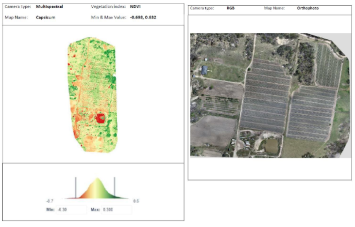
2. Analyse the given NDVI map of the capsicum farm. Address the following points:

Figure 2: Left - NDVI map of the capsicum farm, highlighting vegetation health with color-coded indices. Right - Orthophoto of the capsicum farm, providing an aerial view of the site for comparison.
Write a detailed essay on a real-world application involving a thermal sensor, encompassing all steps from planning to execution and justifying each selection made.
Follow the instructions below to complete the task:
1. Case Study Selection: Choose a project using a thermal sensor in areas like environmental monitoring, agriculture, construction or any other relevant field.
2. Your answer should include:
Buy Answer of SVY2202 Assignment 2 & Raise Your Grades
Pay & Buy Non Plagiarized AssignmentFacing challenges with your SVY2202 Photogrammetry and Drone Mapping Assignment 2? Well! Stop worrying now. You are at the right place. Our platform provides assignment help. We have experienced writers who provide high-quality, no-plagiarism assignments with 100% original content, and we are assured that our Australia Assignment Help will make you productive and help you achieve high grades in your academic year. And we also provide free assignment samples that content has been written by the phd expert writers Contact us now!
Hire Assignment Helper Today!
Let's Book Your Work with Our Expert and Get High-Quality Content
