| Category | Assignment | Subject | Education |
|---|---|---|---|
| University | University of Southern Queensland | Module Title | SVY2202 Photogrammetry and Drone Mapping |
| Assessment Title | Assignment 1 |
|---|

1. Citing reference is required for any ideas/concepts/information obtained from external sources. Be aware that referencing is not about copying ‘word for word’ from a reference. It is about obtaining ideas/concepts/information and presenting it in your own words (i.e. paraphrasing) while acknowledging the source as a reference.
2. Listing the references at the end does not mean you have used them. The intext citation is critical whenever you use those references. If you are unsure about the method of in-text citation, please refer to the Harvard AGPS referencing guide in web link indicated above.
3. Do not put Web references (URLs) within the text. Instead, identify the author/owner of the Web site and cite it in-text while providing full details in the reference list.
4. Do not provide references after each question. A full reference list should be provided in alphabetical order at the end of the Assignment document.
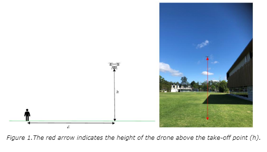
The provided portrait image was captured using a smartphone camera equipped with a 5mm lens and a 1/2.3" sensor (6.17mm × 4.55mm) at a drone distance of 25 meters (d in figure 1) .
Using this information, determine:
1. Compute the Field of View (FOV) (horizontal and vertical) , the base coverage (horizontal and vertical) for the given camera specifications at the given drone distance.
2. Estimate the height of the drone above the ground using proportional measurements from the captured image.
3. Calculate how the base coverage changes at decreasing distances (20m,15m,10m) and determine when the drone would no longer fit within the image frame.
4. Repeat the calculations (1-3) using a different focal length (10mm) while keeping the same sensor size.
5. Discuss how factors such as focal length and sensor size impact the ability to capture the drone at further distances.

Stuggling Your SVY2202 Assignment 1? Deadlines Are Near?
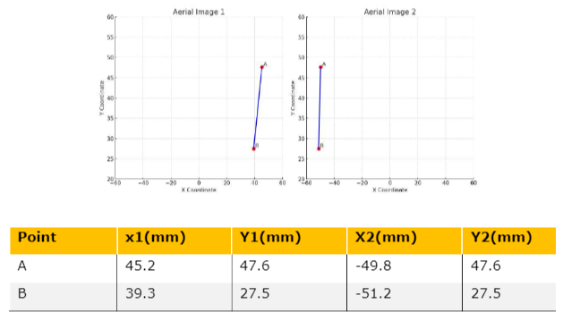
Hire Assignment Helper Now!A bridge appears on a pair of overlapping vertical photographs (1 and 2) as shown below:
(a) Determine the length and slope of the bridge from the following data and absolute parallax measurements.
The Known data includes:

b) If the camera focal length was changed to 200mm, how would the results differ? repeat the calculations and discuss how does an increase in focal length affect parallax, ground coordinates, and slope accuracy?
Calibration involves deriving various parameters crucial for accurate photogrammetric processing. This question focuses on camera calibration using the Agisoft Metashape software. The calibration process will encompass statistical and graphical assessments of the results, considering factors such as nominal focal length, pixel size, and the impact of calibration parameters, especially radial distortion, on ground coordinates and image scale.
1. Pre-calibration Preparation:
2. Calibration Process:
3. Initial Calibration and Results:
4. Checking and Corrections:
5. Comparison and Analysis:
Results and Conclusion: Compile a comprehensive discussion detailing the calibration process, the impact of the number of images on calibration results, and an analysis of the derived parameters. Discuss the practical implications of the findings and compare them against the manufacturer's specifications for the camera.
An aerial survey is planned to cover a 600m (E/W) by 200m (N/S) area using a camera with a focal length of 35mm, an image resolution of 24 MP (6000 × 4000 pixels), and a pixel size of 3 × 3 microns. The flight is designed to achieve a Ground Sampling Distance (GSD) of 3 cm/px while maintaining a 75% forward overlap and 65% side overlap between consecutive images. The aircraft is flying at a speed of 10 m/s. Given the provided information, answer the following:
1. Flight Planning:
o Determine the required flying height above mean terrain to achieve the specified GSD.
o Calculate the photo scale of the images captured.
2. Coverage Calculation:
o How many flight runs (E/W) are required to ensure full area coverage?
o How many photos per run (N/S) are needed to maintain the required overlap?
Order Custom Answers for SVY2202 Assignment 1
Order Non Plagiarized AssignmentLooking for expert guidance in SVY2202 Photogrammetry and Drone Mapping Assignment 1? Worry, no need! We are here to help you with assignments. Whether you need australia assignment help or well-structured solutions, we will provide everything. You will get free assignment examples that will make your study material stronger. Our expert team is providing all assignment services, you will get accurate, clear, and original content. Now stop worrying about marks and complete your assignments hassle-free with expert support. So what's the delay? Get connected with us now and make your academic journey easy!
Hire Assignment Helper Today!
Let's Book Your Work with Our Expert and Get High-Quality Content
