| Category | Assignment | Subject | Engineering |
|---|---|---|---|
| University | Western Sydney University | Module Title | CIVL4017: Surface Water Hydrology |
The progress reports and final reports are group online submissions made via Turnitin. Only one report is required per group. However, if multiple submissions are made, only one report from the group, selected at random, will be marked. Along with the group final project report submission, individual self- reflection report must also be submitted online. The self-reflection report needs to clearly identify contributions made by the student to the project and the lessons learnt. W h i l e these pages will not count towards the word limit, the reflection report will need to be concise.
Each submission will need to include all associated computations (spreadsheets and all software related files, as necessary).
Refer the Subject Outline for detailed marking criteria and standards.
Make justifiable and meaningful engineering assumptions, where necessary.
Use the average of the last digits of your team members’ student ID to determine the catchment to be used for the project.
If the average is between 0 & 3 ( , use catchment A If the average is between 3 & 6 ( , use catchment B If the average is between 6 & 9 ( , use catchment C
For example,
Estimates of all areas of the catchment can be made using either a software of your choice or any other standard engineering method you are familiar with, including the grid approach. An approximate estimate suffices - use the scale shown in the figure for estimation.
Catchments A, B & C are shown in Figures on the next three pages.
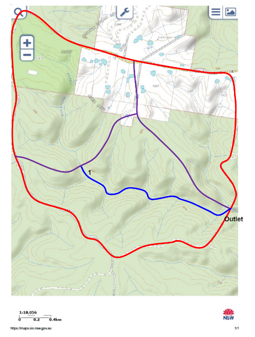
Fig. 1. Catchment A: 3 sub-catchments; 1 & Outlet are outlets of the three sub- catchments, Centroid of the catchment is at: 150o34’52” E Longitude, 33o31’34” S Latitude
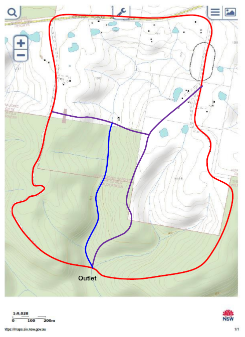
Fig. 2. Catchment B: 3 sub-catchments; 1 & Outlet are outlets of the three sub- catchments, Centroid of the catchment is at: 150o36’16” E Longitude, 33o31’25” S Latitude
Stuck Your CIVL4017 Assignment ? Deadlines Are Near?
Hire Assignment Helper Now!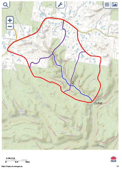
Fig. 3. Catchment C: 3 sub-catchments; 1, 2 & Outlet are outlets of the three sub- catchments, Centroid of the catchment is at: 150o31’17” E Longitude, 33o31’25” S Latitude
The project has been formulated to allow you to determine the differences in catchment responses before and after development. The catchment currently is undeveloped and one of the three sub-catchments is proposed for development. It is up to your team to decide which sub-catchment you want developed. You will need to identify the sub-catchment for development in your report.
While it will be helpful to follow the step-by-step (each task identified) process to solve the problem, it is not mandatory to follow these steps. The final submission (project report) will need to be in a technical report format.
Estimate the area of each sub-catchment. (Use of Nearmap will be helpful) Estimate the total catchment area (don’t be pedantic, an approximation suffices). Estimate the length of channels. This will be different for different catchments.
For catchment A and B, you will need to estimate lengths of one channel (1 to outlet) whereas for catchment C, the lengths of two channels (1 to 2, and 2 to outlet) are required.
Use the Bureau of Meteorology web site to generate the family of IFD curves for your catchment.
Use the 2016 IFD and the latitude and longitude stated in the figures (for your catchment) to generate IFD information for your site. Use 1% AEP 6-hr storm for further analysis. You will need to include both the IFD table and IFD curves in your report – your team can decide whether to include these in the body of the report or as appendices.
Use the ARR Data Hub web site to generate total rainfall hyetograph for the storm generated in the above step. You will need to include the total rainfall hyetograph, both table and histogram, in your report.
Extract the initial and constant loss values from the ARR Data Hub web site. Make necessary adjustments and construct the rainfall excess hyetograph. You will need to explain how you achieved your result and include this in your report. Graphical representation suffices here.
Assume one of the sub-catchments will be developed. For post-development condition, assume that both the initial loss and continuing loss are reduced by 50% for the sub-catchment you’re proposing to develop.
Remember you’re developing only one of the three sub-catchments therefore loss values and rainfall excess will change only for one sub-catchment.
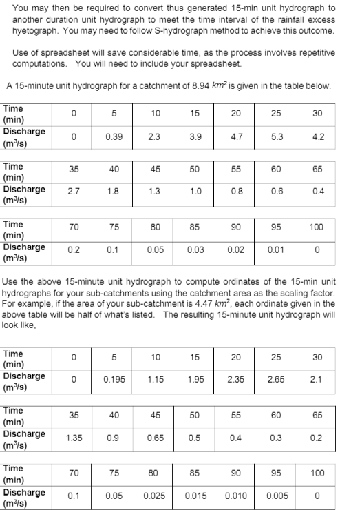
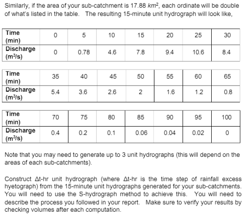
Construction of unit hydrographs of desired durations You will be generating 15-minute unit hydrographs for your sub-catchments using the 15-minute unit hydrograph for a 8.94 km2 catchment given in the table below and making reasonable assumptions (explained below).
Achieve Higher Grades of CIVL4017 Assignment & Raise Your Grades
Do you need help on a CIVL4017: Surface Water Hydrology Assignment? Then no need to worry! Our team of experts provides the Australia Assignment Help designed for students. We are here to assist you 24/7. We provide the Civil Engineering Assignment Help And We will deliver your assignment before the deadline with well-researched results. We also provide free assignment samples written by PhD expert writers. Contact us now and boost your academic grades!
Hire Assignment Helper Today!
Let's Book Your Work with Our Expert and Get High-Quality Content
